


NH Fire Danger
|
IMPORTANT: Always check with your state fire rangers and local fire departments and wardens for the latest official information. This web page is a unofficial copy of the most recent email, and may not always be up to date. The text is lightly edited for clarity and timeliness. Email issued by the NH Division of Forests & Lands; learn more and sign up for email alerts at their site, |
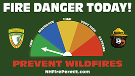
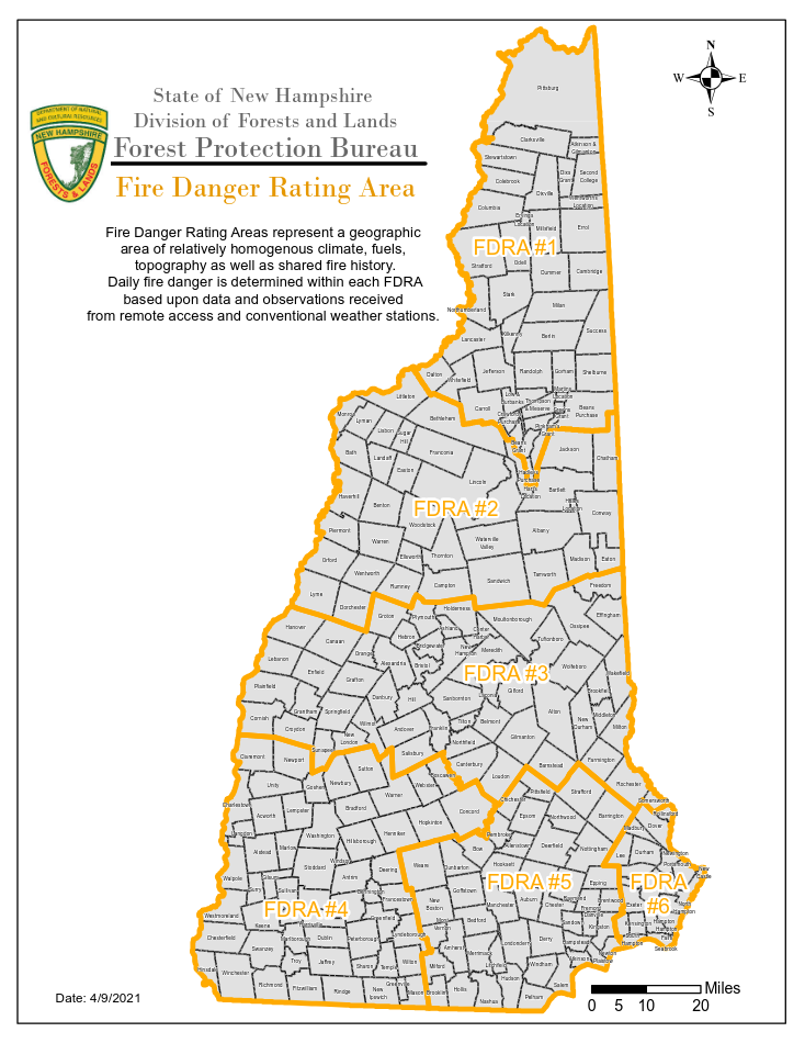
FDRAs 1-6 LOW Fire Danger (for areas without snow) Synopsis: TODAY...Cloudy with a 50 percent chance of rain showers. Highs in the upper 50s. South winds 10 to 15 mph with gusts up to 30 mph. Minimum relative humidity around 69 percent. TONIGHT...Cloudy with rain showers likely. Lows in the mid 30s. Chance of rain 70 percent. Southwest winds around 15 mph with gusts up to 30 mph increasing to west around 25 mph with gusts up to 40 mph after midnight. *Extended Fire Weather Forecast:* TUESDAY...Partly sunny. Cooler with highs in the lower 40s. Northwest winds 20 to 30 mph with gusts up to 60 mph. Minimum relative humidity around 27 percent. TUESDAY NIGHT...Mostly clear. Lows around 20. Northwest winds around 30 mph with gusts up to 50 mph decreasing to around 15 mph with gusts up to 30 mph after midnight. WEDNESDAY...Mostly sunny. Highs in the lower 40s. North winds around 15 mph shifting to the south in the afternoon. Minimum relative humidity around 23 percent. WEDNESDAY NIGHT...Rain, freezing rain and sleet with snow likely. Lows around 30. Chance of precipitation near 100 percent. Southeast winds 10 to 20 mph with gusts up to 35 mph. THURSDAY...Rain. Not as cool with highs in the upper 50s. Chance of rain near 100 percent. South winds 15 to 25 mph with gusts up to 40 mph. Minimum relative humidity around 60 percent. THURSDAY NIGHT...Mostly cloudy with a 40 percent chance of rain showers. Lows in the lower 40s. West winds 10 to 15 mph...except west 20 to 30 mph across northern New Hampshire. FRIDAY...Partly sunny. Highs in the upper 50s. Northwest winds 10 to 15 mph...except northwest 20 to 30 mph across northern New Hampshire. Minimum relative humidity around 38 percent. FRIDAY NIGHT...Partly cloudy. Lows in the lower 30s. Northwest winds 10 to 15 mph...except northwest 15 to 25 mph across northern New Hampshire. SATURDAY...Partly sunny. Highs in the upper 40s. Northwest winds 10 to 15 mph with gusts up to 30 mph. Minimum relative humidity around 39 percent. SATURDAY NIGHT...Mostly cloudy with a chance of rain and snow showers. Lows in the lower 30s. Chance of precipitation 30 percent. Southeast winds 10 to 15 mph with gusts up to 25 mph. Also Follow Us On Twitter and Instagram- @NHForestRangers This email newsletter is a service of the State of New Hampshire Department of Natural and Cultural Resources. |
Source: https://www.nhdfl.dncr.nh.gov/sites/g/files/ehbemt866/files/documents/nh-fire-zone.pdf |